http://paulbutler.org/archives/visualizing-facebook-friends/
https://www.facebook.com/notes/facebook-engineering/visualizing-friendships/469716398919
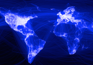
Facebook intern Paul Butler was interested in the locations of friendships, so he decided to create a visualization of Facebook connections around the globe. How local are our friends? Where are the highest concentration of friendships? How do political and geological boundaries affect them?
Butler started by using a sample of 10 million friend pairs, correlated them with their current cities and then mapped that data using the longitude and latitude of each city.
http://mashable.com/2010/12/13/facebook-members-visualization/